
One of Southeast Asia’s greatest road trips is the Ha Giang Loop Vietnam, which refers to a lengthy, narrow road with elbows that connects the starting point to the finish line, forming a closed circle. Specifically, this dusty tourist road has been ranked among the world’s most spectacular backpacking routes
The acticle will be dedicated to those who are passionate about exploring the pristine and majestic beauty of the Northern mountainous region of Vietnam. Ha Giang Loop, with its winding roads around rocky mountains, increasingly attracts adventurous travelers and nature lovers. It’s not only a challenging journey on winding and difficult roads, but also an opportunity to explore the culture, people, and magnificent landscapes of this land. Let’s discover and experience the wonders of Ha Giang Loop together, one of the must-visit destinations when you set foot in Vietnam

Discover Ha Giang Loop Vietnam – Your Ultimate Adventure Awaits!
1. Ha Giang Location
Vietnam’s northeastern province of Ha Giang is mountainous. This province shares borders with the provinces of Cao Bang to the east, Yen Bai and Lao Cai to the west, Tuyen Quang province to the south, and China to the north. The overall natural area of Ha Giang is 7,884.37 km2, of which the largest portion is 115 km long from east to west and 137 km long from north to south, as the crow flies. Situated around 3 kilometers east of Lung Cu, Ha Giang province is home to the northernmost point of the nation. Ha Giang is referred to as the Fatherland’s prime land as a result.
2. Vietnam Ha Giang Loop Weather
The weather in Ha Giang can only be described as unpredictable, therefore it’s important to be ready for a variety of scenarios. Depending on your interests and the experiences you want to have, there is no set optimal time to visit Ha Giang. While June to August might be unbearably hot and rainy, November to March can be very chilly. Because October brings with it the chance to see the Tam Giac Mach flowering season, it is a popular month to visit. But bear in mind that the weather might change from year to year, so it’s best to plan ahead and bring clothing for every eventuality.
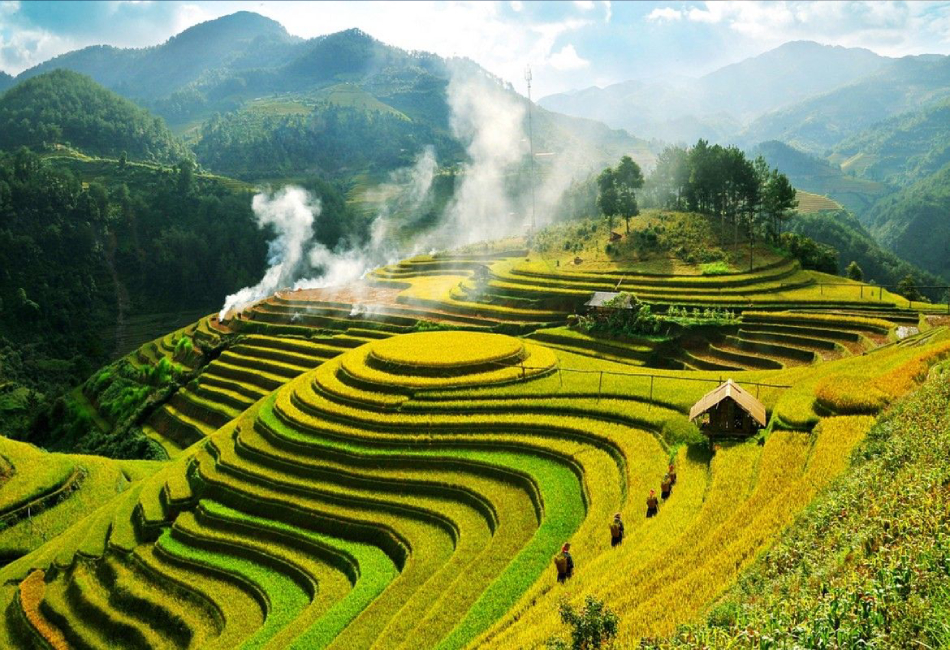
As you are aware, Ha Giang is a fairly large region with a diverse population of ethnic minorities. Ha Giang offers something new every month. Arriving in Ha Giang in the start of the year allows you to fully experience the local atmosphere. You decide to visit Ha Giang during the summer, when there are many amazing sights to see, such as the Nho Que river and terraces.

3. Ha Giang Loop Price
It is not expensive to visit the Ha Giang Loop from Hanoi; if you choose to do it yourself, the daily cost will range from 50 USD to 70 USD, depending on your choice of motorbike and lodging. This is the daily average price for Ha Giang Loop
Rent a Motorcycle: for 7 USD to 17 USD a day.
Fuel: around 200,000 VND (8 USD)
Lodging: 30 USD a night
Loop Permit for Ha Giang: 10 USD per motorcycle
Water, snacks, and meals: about 100,000 VND
4. Ha Giang Loop Route
4.1 Ha Giang City to Yen Minh
The scenery changes as you drive Highway 4C north of Ha Giang, revealing limestone mountains covered in dense vegetation. The Dong Van Karst Plateau, a UNESCO Global Geopark, will soon be reached. Take an exciting trip to Heaven’s Gate Pass, where you can test your mettle on treacherous roads and take in the breathtaking views. For those who are visiting Ha Giang Loop for the first time, this is a special chance. Reaching Tam Son from Heaven’s Gate Pass will bring you to a village encircled by protruding hills covered in forest. Proceed in the direction of Yen Minh along National Highway 4C. The route crosses a steep gorge after following the picturesque Mien River. Before reaching Yen Minh, race swiftly via mountain passes and limestone plateaus.

This location features a changing landscape throughout the day. This location is covered in fog and white clouds in the early morning, which creates a really ethereal and enigmatic image. You will be able to hunt the stunning sea of clouds if you arrive at the top of the hill between 4 and 5 am. By midday, the pine trees were flooded with sunlight. Now that the fog had mostly lifted, the sun appeared to be waking the enormous pine forest. The drops of morning dew that are still on the foliage are now incredibly glittering.
The pine woodland has a serene, even nostalgic appeal in the afternoon. The last of the sunshine filtered in between the perfectly spaced rows of pine trees, then slowly disappeared. The “golden” period for taking incredibly creative pictures is now

4.2 The Vietnamese Border
Proceed to the northeast on QL4C. As soon as the steep trail rises beyond the tree line, an unearthly scene of crumbled limestone mountains and breathtaking views can be seen around every corner. A wonderful spot to pause and take in the twisting roads that progressively descend into the valley below is Doc Chin Khoanh (Chin Khuc Pass). You will reach the Lung Cu Flagpole after three hours.
The Lung Cu flagpole marks the border between China and Vietnam. Visit the Lung Cu Ha Giang flagpole while also taking in the breathtaking scenery that surrounds it. At the Fatherland location, one of the most well-known historical “witnesses” is also up for touch. Furthermore, two year-round, year-round ponds on the mountainside are visible when gazing down at the earth from the top of the flagpole. The indigenous population refers to this as the “dragon’s eyes,” and local ethnic groups also use this water source.
Try the 360-degree views of the border between China and Vietnam here at least once. Once you get back to National Highway 4C, you may take in a lot of the breathtaking scenery en route to Dong Van.

4.3 Dong Van and Ma Pi Leng Passes
Morning is the time when you will go on what is considered the most spectacular road in Vietnam. From Dong Van to Ma Pi Leng Pass, the valley floor seems to disappear below as you pass through majestic peaks and canyons. The only problem is that you have to consider how many times you stop to take photos because there are so many poetic scenes at every turn.
Meo Vac is only 24 km from Dong Van, but it will take you most of the morning to get there if you stop for panoramic views along the way. Once there, enjoy this quaint town with its many colors.

Turn left onto minor road 193A from QL4C at the end of Ma Pi Leng Pass for a short detour. This is a small distance, but it’s very intriguing because you can see the Nho Que river’s twisting course up close. You can stop here to take pictures from above if you are unable to travel down to the Nho Que river to see Tu San Alley from below. This spot used to be only a sheer cliff with a treacherous path down; most of the time, only young people would climb out to snap pictures. Later, as the number of visitors grew, this location was converted into a store selling regional specialties and equipped with stairs for visitors’ convenience.
You will spend the night in a little town in Bao Lam, where the locals will extend a hearty welcome to you. After unwinding for a few hours in this secluded area, prepare for the following morning’s journey back to Ha Giang.

4.4 Back to Ha Giang City
Travel Highway 34 southwest toward Ha Giang from Bao Lam. Traveling down the valley floor is enjoyable as the road primarily follows the Gam River. Although there will still be some turns and passes on the way back to Ha Giang, it won’t be as hazardous or winding as the original route.

5. Ha Giang Loop Vietnam Tips
Here are some things to consider while you’re heading to Ha Giang Loop:
- Pack warm clothing, ideally a hooded jacket so you can quickly adjust to the two highland areas of Meo Vac and Dong Van.
- Pack a small medicine pack with eye drops, plaster, flu medication, and wind oil. Remember to pack a raincoat and a travel-specific compact vehicle pump.
- In your backpack, include some dry food and crackers in case you grow weary or hungry while traveling.
- Keep the phone numbers of the following in your phone book: Ha Giang police, restaurants, lodgings that fit your itinerary, and the leader of your party if you’re traveling in a group.
- Additionally, the driver should have experience, and you should psychologically and physically prepare yourself before the trip.
- You should travel at a modest speed and reduce your speed when you are on a road that has a warning sign for hazard. You should halt your travels temporarily if there is a storm.

The Ha Giang Loop is a once-in-a-lifetime adventure that highlights Vietnam’s natural splendor and cultural diversity. You will be enthralled with Ha Giang’s unspoiled splendor as you take in the breathtaking scenery and meandering roads. The Ha Giang Loop offers an experience full with lifelong memories, whether you decide to go on your own or take a guided trip. So gather your belongings, get on your bike, and set out on an adventure that will reveal Ha Giang’s little-known gems to you. If you are planning an upcoming trip to Sapa, you can join VM Travel to discover the best of the Ha Giang Loop Vietnam tour.
0 Comment